Updated 5:45 p.m.: Winter Storm and Flood Watches Issued
The National Weather Service has issued a winter storm watch for western and central Oklahoma as a strong storm system approaches the state.
Forecasters say the watch will be in effect from Saturday evening through Monday. Forecasters said Thursday that the storm is expected to produce snow and ice accumulations of 4 to 10 inches.
In addition, ice accumulations due to freezing rain could reach three-quarters of an inch, especially along Interstate 44. Forecasters say strong northerly winds could also create white-out conditions across portions of western Oklahoma. Gusty conditions may contribute to an increased number of power outages across the region, even if only light icing amounts occur.
Forecasters have also issued a flash flood watch beginning Friday night for areas of southern and eastern Oklahoma and northwestern Arkansas.

Original Post:
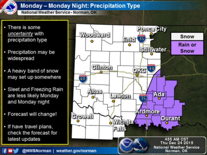
Forecasters at the National Weather Service in Norman say a winter storm will likely affect parts of Oklahoma this weekend. There is a still quite a bit of uncertainty about the storm's track at this point, but forecasts believe it is quite possible that winter weather will have significant impacts across the area.
Rain will begin to develop in southeast Oklahoma on Christmas day, but the chance for precipitation increases during Christmas evening. On Saturday, heavy rainfall is possible in north-central Texas and southeast Oklahoma. Strong to severe storms will be possible Saturday.

It is still too early to tell the location of of significant winter weather impacts because the primary storm system has not yet developed. The greatest chance for heavy winter weather is in northwest Oklahoma, but the storm system could potentially move southeast to central or southeast Oklahoma.
A cold front will move across northwest Oklahoma on Saturday morning, moving south through Saturday afternoon and evening. Currently, the forecast indicates winter weather will primarily consist of snow on Saturday night and Sunday morning in northwest Oklahoma. Central and southern Oklahoma will primarily receive rain at that time. Freezing rain and sleet will be possible in the transition area between snow and rain.

As the system moves southeast, winter weather can be expected in much of the area by Monday. At this time, only parts of south-central and southeast Oklahoma are expected to only receive rain.

It's too early to have confident precipitation total forecasts at this point, but forecasters say a potentially significant winter storm will likely affect northwest and west-central Oklahoma with nearly a foot of snow. Areas to the southeast are expected to receive less snow, but this could change.

KGOU is a community-supported news organization and relies on contributions from readers and listeners to fulfill its mission of public service to Oklahoma and beyond. Donate online, or by contacting our Membership department.


